Rural Oklahoma Experiences “One Of The Most Powerful Tornadoes Ever” Recorded
on May 03, 2024 • Updated Jan 15, 2025

“One of the most powerful tornadoes ever” hit southwest Oklahoma Tuesday night, but will likely never receive Fujita Scale rating due to it touching down in an unpopulated area.
Parts of the midwest have faced utter devastation in recent days as Oklahoma, Nebraska, Iowa and Kansas have been hit with tornadoes, some the likes of which have never been seen before.
Multiple large and dangerous twisters pummeled the area and resulted in dozens of injuries and a confirmed four casualties Saturday night alone. The town of Sulphur, Oklahoma, was nearly wiped off the map when it was hit by what has been estimated as an EF-3 tornado.
Even stronger storms struck Tuesday night, and storm chasers and meteorologists experienced two weather phenomena that they had never witnessed before.
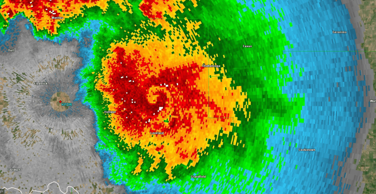
The first was a massive tornado that developed over southwest Oklahoma, just north of the town of Loveland. Radar imagery and a computer algorithm showed that the twister registered a rotational velocity of 127.5 knots, making it the third highest ever recorded. Storm chaser Reed Timmer reports that the large wedge tornado became almost stationary, battered the area for nearly an hour, and registered wind gusts of up to 210 mph.
Imagine intercepting a nearly stationary violent wedge #tornado in the Dominator 3 and being inside it for an hour, getting battered by 150 mph winds with gusts over 210 pic.twitter.com/f3F6YEysBX
— Reed Timmer, PhD (@ReedTimmerUSA) May 1, 2024
“The tornado was so powerful that it prevented rain from falling within its circulation, literally suspending droplets and creating a ‘doughnut hole’ on radar that towered to 18,000 feet. That’s virtually unheard of,” the Washington Post reported.
Weatherman Zachary Hall called the tornado “one of the most powerful tornadoes ever” in a post on X. He added that it will likely “go down in lore with some mystery behind it” due to the fact that it touched down over open farmland and will likely never receive an official rating because surveyors use damage left behind to determine the strength of the storm.
The Loveland twister quickly earned the nickname “land hurricane” due to its size, its appearance on radar, and the fact that it registered near-Category 5 hurricane wind speeds.
This has been the craziest night of my life… pic.twitter.com/XlsFDvS0BT
— Jigsaw (@Jigsaw9051Wx) May 1, 2024
In another bizarre weather encounter, the same storm produced a smaller tornado that spun clockwise instead of counter-clockwise.
Termed “anticyclonic,” the rare twister was one for the history books as less than half a percent of all significant tornadoes have that characteristic.
The backward-spinning tornado baffled storm watchers and meteorologists, many of whom had never witnessed such an event. So few anticyclonic tornadoes have been recorded that there is little information about them. Damage reports indicate that this twister registered as a high-end EF-1 with estimated winds of 110 mph and a path that measured 1200 yards wide and 5 miles long.
Here’s the incredible radar loop of the Fujiwara effect of anti-cyclonic tornadoes.
You can see that textbook RFD surge at the beginning that produced the first large rain-wrapped tornado and seemingly spinning off a strong Anti-cyclonic tornado moments later to it’s south!… pic.twitter.com/AAaC49gj0N
— StormHQ ☈ (@StormHQwx) May 1, 2024
Some outlets report that the massive tornado that hit north of Loveland was also anticyclonic, making it extremely rare. But others say that the huge wedge “looped backward and retraced its previous path.”
Learn more about this rare tornado occurrence in the video below.
If you would like to donate to help those affected by the Oklahoma tornadoes, visit Oklahoma Voluntary Organizations Active In Disaster to contribute.


