Gulf States Brace For First Hurricane In 2 Years As Isaias Strengthens

on • Updated
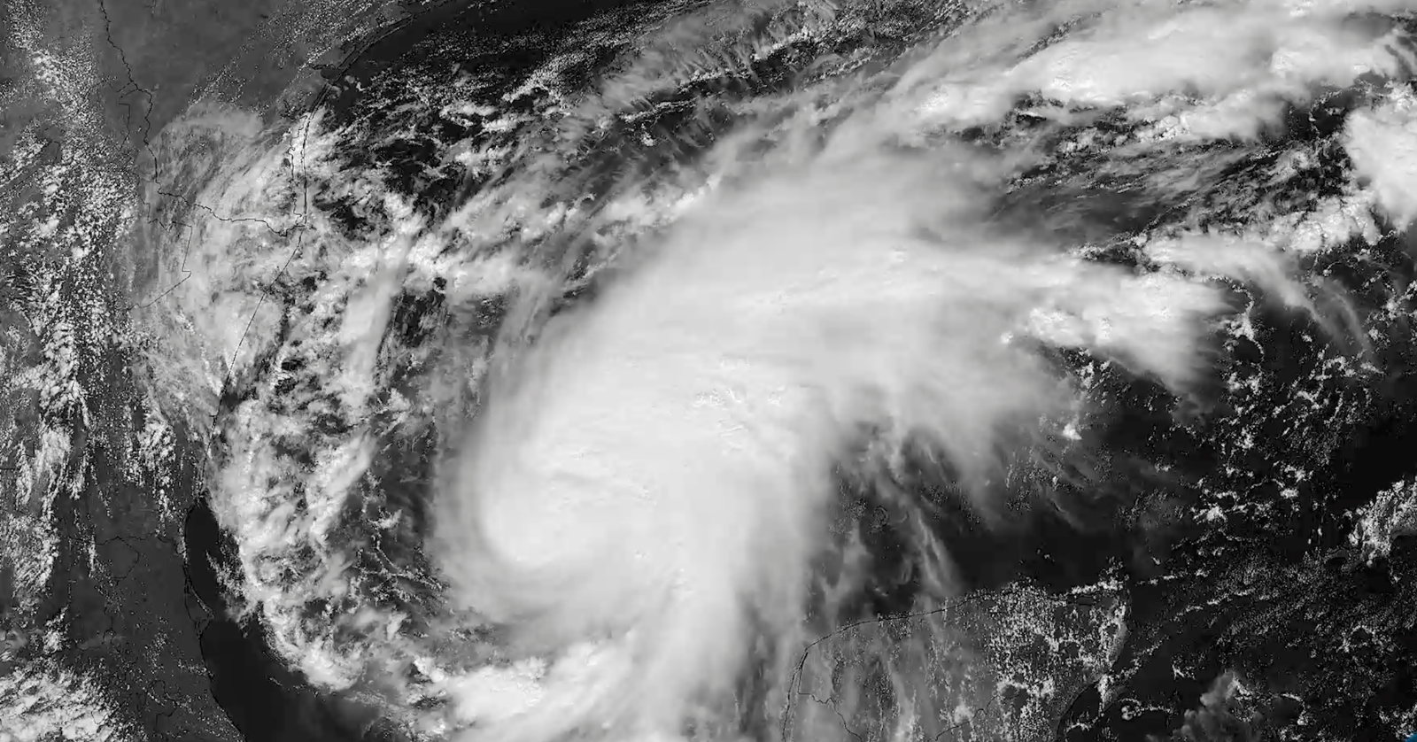
Several states along the Gulf of America are bracing for the first hurricane of the Atlantic hurricane season.
Tropical Storm Isaias, which strengthened to a Category 1 hurricane on Thursday, Oct. 8, is expected to make landfall as a Category 2 on Friday, Oct. 9, with projected maximum sustained winds of 80 mph.
The New York Times, as well as CNN, have reported that there’s a chance it may strengthen to the “low end” of a Category 3.
Not only is it be the first hurricane of the Atlantic 2026 hurricane season — coming in four months after hurricane season began — but it is expected to also be the first hurricane to come ashore since Hurricane Milton in October of 2024, which came just a couple weeks after Hurricane Helene in September of 2024.
In an 8 a.m. EST Oct. 8 bulletin, the National Hurricane Center (NHC) advised that “preparations to protect life and property from storm surge and damaging winds along the warning area of the Gulf Coast should be rushed to completion today.”
Warnings have been issued by NHC, as of the morning of Oct. 8, for the following areas:
- A Storm Surge Warning is in effect for the mouth of the Mississippi River to the Steinhatchee River, Florida;
- A Hurricane Warning is in effect for Ocean Springs, Mississippi, to the Bay/Gulf County Line, Florida;
- A Tropical Storm Warning is in effect for Jefferson/Plaquemines Parish Line, Louisiana, to west of Ocean Springs, Mississippi;
- A Tropical Storm Warning is in effect for East of Bay/Gulf County Line to Aucilla River, Florida; and
- A Storm Surge Watch is in effect for Steinhatchee River to Yankeetown, Florida.
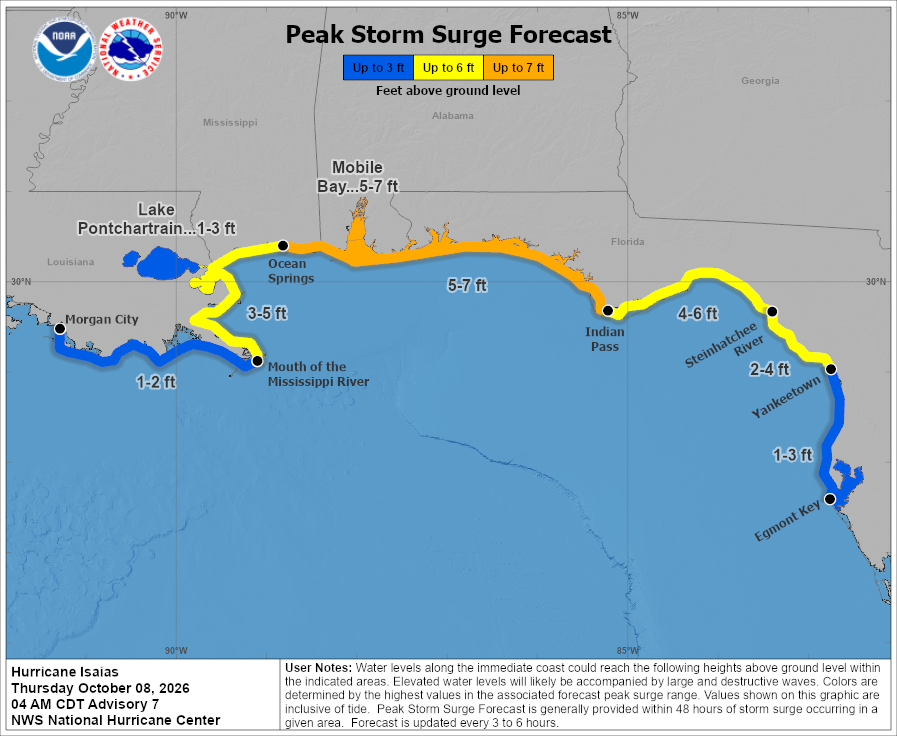
In a graphic made by NHC, water levels are shown along the coast of Alabama and some of Florida being as high as five to seven feet above ground level.
Here’s the NHC graphic which illustrates projected water levels as Isaias makes landfall:
RELATED: Trump Administration Issues $500 Refund Checks… And More Money Could Be On The Way
Gulf States Prepare For For First Hurricane Impact In 2 Years
While the exact location of landfall for Hurricane Isaias is not yet known, the tropical storm’s wide path is expected to impact Louisiana, Mississippi, Alabama, and Florida in a direct manner.
See the storm’s size and trajectory, as of the morning of Oct. 8, here:
[10/8 10AM] 🌀 Hurricane Isaias continues to gather strength over the Gulf & is expected to turn north toward the northern Gulf coast tonight. 📉 Weather conditions will gradually worsen thru the day Friday. ‼️ Complete preparations in watch and warning areas by Friday morning! https://t.co/2y8PAEPZRv
— NWS New Orleans (@NWSNewOrleans) October 8, 2026
According to CNN, Mobile, Alabama, can anticipate six to 10 inches of rain, with peak impact being in the late afternoon of Oct. 9 and going into the morning of Saturday, Oct. 10.
Responding to this possibility, Alabama Gov. Kay Ivey declared a state of emergency for 40 counties in Alabama, saying:
“While we continue to monitor forecasts, we have to prepare now. That is why I have issued a state of emergency for 40 counties. This will allow us to take any needed steps ahead of landfall. As we approach the weekend and any travel plans, make sure you have reliable information as conditions develop. While I hope for minimal impacts, we must take preparations seriously.”
See her full Oct. 7 statement regarding the state of emergency in 40 Alabama counties, here:
I have issued a state of emergency for 40 counties. Forecasts continue to show the real likelihood that the tropical system brewing in the Gulf could impact Alabama as a hurricane as early as Friday. While I hope for minimal impacts, we must take preparations seriously. #alwx https://t.co/GFidkQUXO0
— Governor Kay Ivey (@GovernorKayIvey) October 7, 2026
Similarly, CNN reports that Hurricane Isaias is expected to impact Pensacola, Florida, in the late afternoon of Oct. 9, with high tide expected at 11 p.m. EST.
Winds are expected to range from 80 mph to 100 mph, CNN projects.
Florida Gov. Ron DeSantis declared a state of emergency for 25 counties on Oct. 7.
See DeSantis’ statement regarding the state of emergency for 25 counties in Florida, here:
Today, I signed Executive Order 26-202, declaring a state of emergency for 25 counties in preparation for Tropical Depression Nine. This order ensures communities have the time and resources necessary to prepare for potential severe weather impacts to the Panhandle and Big Bend region of Florida. Floridians should have their plans in place, keep emergency supply kits fully stocked, and follow @FLSERT for weather updates and preparedness information.
— Ron DeSantis (@GovRonDeSantis) October 7, 2026
Counties included in the state of emergency in Florida are, as follows: Baker County, Bay County, Calhoun County, Columbia County, Dixie County, Escambia County, Franklin County, Gadsden County, Gilchrist County, Gulf County, Hamilton County, Holmes County, Jackson County, Jefferson County, Lafayette County, Leon County, Liberty County, Madison County, Okaloosa County, Santa Rosa County, Suwannee County, Taylor County, Walton County, Wakulla County, and Washington County.
Regarding New Orleans, Louisiana, CNN reports that the peak impact may be as early as the morning of Oct. 9, with the storm expected to continue through Saturday morning.
Peak gusts of wind will range from 35 mph to 45 mph.
In Mississippi, the Mississippi Emergency Management Agency (MEMA) is “urging residents across the state to begin preparing now for Tropical Storm Isaias,” it said in an Oct. 7 news release.
As quoted in the news release, MEMA Executive Director Stephen McCraney said, “The threat is real, and now is the time to prepare. We have seen how quickly tropical systems can impact Mississippi. Tropical Storm Arthur in June brought tremendous amounts of rain, flash flooding and significant damage.”
See CIRA satellite video of Hurricane Isaias building up, from Oct. 7, here:
Tropical Storm Isaias continued to strengthen in the Gulf today, and is on the verge of becoming a hurricane. https://t.co/vhugMXNUAF
— CIRA (@CIRA_CSU) October 8, 2026
This is a developing story.
RELATED: Trump Announces Change To Trump Accounts That Could Benefit Over 70 Million Americans